3D RADAR imagery for forest monitoring, for REDD-MRV
Others
View/
Date
2016-09Metadata
Show full item recordCollections
- Divisjon for skog og utmark [520]
- NIBIO POP [304]
Abstract
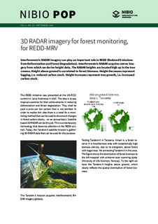
Interferometric RADAR imagery can play an important role in REDD (Reduced Emissions from Deforestation and Forest Degradation). Interferometric RADAR acquires stereo imagery from which we derive height data. The RADAR heights are located high up in the tree crowns. Height above ground is correlated to forest biomass. Height decreases represent logging, i.e. reduced carbon stock. Height increases represent tree growth, i.e. increased carbon stock.